
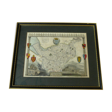
Hand-colored engraved map of Cheshire County by Thomas Moule
€420
Pay in 3 or 4x with

Hand-colored engraved map of Cheshire County by Thomas Moule
€420
Thomas Moule's county maps were originally published in 'The English Counties Delineated' between 1830 and 1837, representing the golden age of decorative British cartography. These maps are distinguished by their ornate borders, heraldic shields, and vignettes of local landmarks, combining geographical accuracy with artistic embellishment. Moule's maps of English counties became highly sought after by collectors of historical cartography, British history enthusiasts, and decorators seeking authentic period pieces. These maps appeal to those interested in genealogy, local history, and the evolution of British mapmaking, as well as interior designers who value their decorative qualities and historical authenticity.
🇬🇧 EDWARD M.Private sellerSee the shop
New sellerThis seller is starting on Selency, and we already love him. Go for it ❤️
Earth globes & geographical maps: other similar vintage pieces
Discover more similar items- Sold out
- -28%
- -10%
- -27%
- -12%
- -75%
- -27%
- -9%
- -33%
- -12%
- -31%
- -43%
- -17%
Item 1 of 20