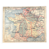
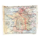
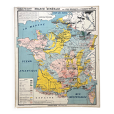
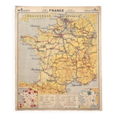
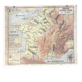
Old school map Vidal Lablache 6, Mézières, T36, 1910 France Canals

- Dimensions :
- H100 x W120
- Color :
- multicolour
- Material :
- paper
- Style :
- vintage
🌐 Old school geography map representing canals and rivers (France) 🌐 Scale 1/750, 000. Original Vidal-Lablache collection. Years 1900/1910. Bookseller Armand Colin, 5 rue de Mézières, Paris. Printer Monrocq, Paris. Print run 36, list of maps up to 39! Mention "General Atlas at the top" and material at the bottom with price in francs. Polychrome cardboard poster. Dimensions: 120 × 100 cm. Front: 6 France canals (Briare, Midi, St Quentin, Aisne, Sambre, Loing, Centre, Berry, Ourcq...) Back: 6 bis Blank map. Medallions: Entire France Canal du Midi, Legend. Dating: before 1913. Armand Colin editions were located at 5 rue de Mézières until 1913 and the publication of Vidal-Lablache maps began in 1885. Alsace and Lorraine (green colour here, mourning) were German from 1871 to 1919 (Treaty of Versailles). The city of Sète was spelled Cette until 1928. Good condition: brass eyelets and fabric border present, beautiful colours, scratches towards the top left corner, other small signs of use and age (see photo). Nicely patinated and of historical interest! Ideal for vintage decoration, collection, or original gift! These maps, both aesthetic and educational, adorned French classrooms from the 1880s to the 1960s and sparked students' imaginations. The so-called blank maps allowed them to test their knowledge. Map shipped carefully in thick cardboard cut to size in France or abroad. FREE SHIPPING FOR THIS MAP (in France, via Mondial Relais or Colissimo). For abroad, costs will be calculated based on the destination (international Colissimo). Contact me for advantageous rates (Europe, worldwide). All types of payment accepted. Hand delivery possible in Lyon. 6VL10.
Earth globes & geographical maps: other similar vintage pieces
Discover more similar items- -22%