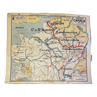
Old illustrated map of Flanders Artois Picardy - JP Pinchon
🙈 Oops, this product is already sold or unavailable. Discover our 1500 new products or products similar to this item !
- Dimensions :
- H24 x W30
- Color :
- multicolour
- Material :
- paper
- Style :
- vintage
Old map of the regions flanders artois picardy, illustrated by émile-joseph-porphyre pinchon (the cartoonist bécassine), extracted from "the provinces of france illustrated", published by blondel la rougery editions. Visible signature of j.p. Pinchon. Date: 1935. Dimensions: 23.5 X 29.7 cm. To be framed. Perfect for a children's room. Lithograph, engraving, painting, decoration, decoration, vintage, gift idea. Geography, france, amiens, somme, abbeville, saint quentin, aisnes, lille, maubeuge, valenciennes, tourcoing, roubaix, dunkirk, calais, boulogne, arras, pas de calais, nord, béthune, montreuil, hazebrouck, st pol, douai, santerre, cambrai.
4.97 ()