Old map of Argentina 1887 – Vintage geographical map

- Dimensions :
- H34 x W26 x D1
- Color :
- multicolour
- Material :
- paper
- Style :
- industrial
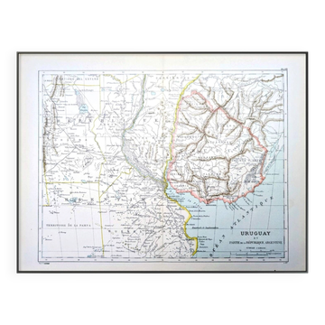
🧭 Travel through time and explore Argentina and its neighboring countries (Uruguay, Paraguay, and Chile) with this superb, colorful, and detailed geographical map. By Richard Eugène Cortambert, born on May 7, 1836, in Charonne and died on January 26, 1884, in Hyères, a French geographer and writer. Printed in Paris in 1887 by the E. Dufrenoy printing house. Discover this beautiful vintage poster, ideal for vintage, retro, and authentic wall decoration. An antique map, engraving, lithograph, poster, or illustration, each piece adds a touch of history and character to your interior. Perfect for travel lovers, explorers, geography enthusiasts, and distant destinations, as well as for fans of botany, nature, ancient art, vintage decor, collecting, and curiosity cabinets. A beautiful way to bring a unique soul to your decor and travel through time and eras. 🗺 These are authentic old prints and not modern reproductions. 📏 Map dimensions: L26 X H34.5cm ⚠️ Original central fold, very discreet (this will be used for shipping) ⚠️ Frame not included! 📦 Fast, protected, and careful shipping. Argentina, Buenos Aires, Patagonia, Tierra del Fuego, Andes Mountains, Argentine Pampas, Rio de la Plata, Mendoza, Córdoba Argentina, Rosario Argentina, Ushuaia, Salta Argentina, South America, antique map Argentina, vintage geography.
Earth globes & geographical maps: other similar vintage pieces
Discover more similar items- -12%
- -11%